
The corner seems to be a widely used unit to explain somebody, how far a location is. Canadians sometimes answer the question how far it will be to So-and-so: „Oh not to far, it’s just around the corner. Eh!“ You must know a real Canadian uses „Eh!“ at least once in a sentence better more. If you get such an answer be prepared that the corner could have a length of some hundred kilometers.
0,06 people per square kilometer
To understand why I want to give you two examples of the dimensions of Canada – that always fascinated me. Canada consists of ten provinces and three territories. The provinces string in the southern part of Canada along the border to the United States of America whereas the territories are located in the northern half touching the Arctic Ocean.
Actually we are staying in Whitehorse the capital of the Yukon Territory, which is the western territory at the border to Alaska. Whitehorse is in the very south of the Yukon Territory a little north of latitude 60°. The population is around 25,000 and another 10,000 inhabit the rest of this territory. So they have indeed a lot of space, as the Yukon is twice as large as the United Kingdom! (Density: Yukon 0.065/km2; UK 255.6/km2)
More than 700 kilometers to the next city
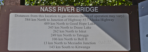
Another example is our trip to the Village of Telegraph Creek in British Columbia (Paradise and retour). Imagine you are living in this gorgeous little village. To reach the next populated place you have to drive 120 km on a gravelled road, but this is just another village with 650 inhabitants. So if you would have to go to town you can choose whether you go to Whitehorse or to Smithers. The first option will be a journey of 760 km northbound and Smithers is closer so you only have to drive 710 km southbound. That is Canada.